Faraday station, formerly known as Argentine Islands, has been operated by Britain on the Antarctica Peninsula since 1947. This report summarises the meteorological observations taken between 1947 and 1995. Faraday was handed over by the British Antarctic Survey to the Ukrainian Antarctic Research Centre in early 1996 and is now called Vernadsky. The WMO number for Faraday and Vernadsky is 89063 and this was changed from 88952 at the start of July 1985.
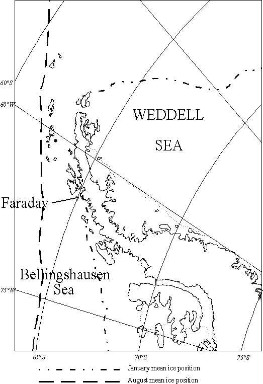
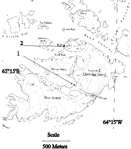
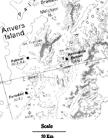
Faraday is situated on a group of islands at 65 15'S 64 16'W on the western side of the Antarctic Peninsula and the barometer height is 11m . Initially it was sited on Winter Island (point 1) and was moved to Galindez Island (point 2) in 1954. Due to its location it has a maritime climate in the summer but in the winter it has a more polar climate with sea ice becoming extensive in the Bellingshausen Sea. Due to the surrounding mountains the winds at Faraday are not representative of the large scale air flow in the area. The wind is funnelled from the northeast by Anvers island and the Antarctic Peninsula both of which reach an altitude of over 2000m. This funnelling effect can be seen in the wind roses. A topographical map showing the location of Faraday and the surrounding mountains is shown in here .
Faraday is approximately situated in the circumpolar trough. This represents the track that most of the depressions take while moving around Antarctica. This means that Faraday's climate is very dependent on cyclonic activity. The circumpolar trough is deepest in the spring and at this time it is also to the south of Faraday. In the summer the circumpolar trough is not as deep but it remains close to Faraday.
It has been shown by King (1) that the mean temperature at Faraday and along the western Antarctic Peninsula has risen about 0.5 C per decade since 1947. There have also been increases in the number of reports of precipitation (Turner et al. (2)). This report is intended to give the researcher an idea of the data that we hold and give some idea as to the month-to-month climatology and trends that we see in the data.
The synoptic observation dataset consists of 8 observations a day (00, 03, 06, 09, 12, 15, 18 and 21UT) of temperature, sea level pressure, relative humidity, wind speed and direction, visibility and cloud information (type, amount and height) and also weather codes that can be used to deduce information on precipitation frequency and type. All the 3 hourly observations from 1956 until 1995 are stored on an Oracle database. In addition monthly mean values for pressure, temperature and wind speed are available from 1947 until 1995.
An upper-air program was carried out at Faraday between 1956 and 1982 with data available from one ascent per day. Also, radiation measurements were carried out between 1963 and 1982 (3).
Intensive quality control has been carried out on all the surface synoptic data by range checking' the observations, looking for large jumps in consecutive observations and comparing different variables to check for internal consistency e.g. looking for decreasing visibility with increasing wind speed, possibly due to blowing snow.
Some measurements e.g. visibility and cloud amount, are more subjective during darkness. Measurements are still recorded but they are not as reliable as when the observations are made in daylight.
Mean monthly values of sea level pressure, temperature, total cloud amount and wind speed can be found here
Up to 1986 manual observations were made; wet and dry bulb temperatures were measured using aspirated thermometers if the wind speed was less than 12 knots and using the screen thermometers if above 12 knots. Wind was measured using Munro wind sensors. Atmospheric pressure was measured using a precision aneroid barometer and the humidity, vapour pressure and dewpoint were calculated from the wet and dry bulb temperatures.
In April 1985 the Synoptic and Climatological Automatic Weather Station (SCAWS) was installed. SCAWS was in a test phase until the end of 1985 and replaced manual observations from January 1986. The old Munro wind recorders were replaced with Vector instrument anemometers and wind vanes that had heated spindles. Temperature was measured using a non-aspirated Platinum Resistance Thermometer (PRT), humidity was measured using a Vaisala humidity probe and pressure was measured using a Rosemount pressure transducer. Meteorological observers entered information about cloud, visibility and present weather as before.
During 1986 the Stevenson screen was resited near the 10m mast upon which the wind sensors were mounted. This was done because the old location of the Stevenson screen was close to the base and it was prone to being covered in snow drifts during the winter. A temperature comparison was carried out between 10/2/86 and 25/3/86 to determine if there was any change in the temperatures measured at the two sites and it was decided that the difference was within 0.1 C
In March 1992 SCAWS was replaced by the current Modular Automatic Weather Station (MAWS). The MAWS PRT was aspirated, the wind sensors were the same as for SCAWS, pressure was measured using a Setra 270 pressure transducer and humidity was measured using a Hy-Cal humidity sensor. MAWS was operated until Faraday was handed over to the Ukrainians.
Below is a table of Long term monthly and yearly means with their respective standard deviations for primary observation variables contained in the Faraday climatological records. The values for pressure and temperature are for the period 1947-1995 and all others are for 1956-1995.
| JAN | FEB | MAR | APR | MAY | JUN | JUL | AUG | SEP | OCT | NOV | DEC | YEAR | |
| Sea Level Pressure (hPa) | 990.8 | 988.4 | 988.5 | 988.8 | 992.6 | 992.2 | 993.0 | 990.9 | 988.8 | 986.2 | 986.3 | 991.1 | 989.8 |
| S.D. | 3.9 | 3.7 | 4.6 | 4.9 | 6.0 | 6.3 | 6.0 | 6.9 | 4.6 | 4.9 | 5.6 | 5.1 | 1.3 |
| Temperature (Deg C) | 0.6 | 0.4 | -0.8 | -3.0 | -5.3 | -7.6 | -9.9 | -10.2 | -8.0 | -5.2 | -2.4 | -0.3 | -4.3 |
| S.D. | 0.8 | 0.9 | 1.0 | 2.3 | 2.4 | 3.0 | 4.9 | 3.7 | 3.0 | 2.0 | 1.2 | 0.6 | 1.5 |
| Humidity (%) | 83 | 82 | 82 | 82 | 81 | 81 | 82 | 82 | 84 | 84 | 83 | 84 | 82 |
| S.D. | 6.4 | 5.7 | 4.5 | 5.1 | 5.9 | 6.8 | 6.8 | 7.7 | 6.9 | 6.9 | 5.3 | 7.1 | 4.6 |
| Vapour Pressure (hPa) | 5.4 | 5.3 | 4.9 | 4.3 | 3.7 | 3.3 | 2.9 | 2.8 | 3.3 | 3.8 | 4.4 | 5.1 | 4.1 |
| S.D. | 0.5 | 0.5 | 0.4 | 0.6 | 0.6 | 0.6 | 0.8 | 0.7 | 0.6 | 0.6 | 0.5 | 0.5 | 0.4 |
| Wind Speed (Knots) | 5.2 | 6.5 | 7.9 | 8.1 | 7.8 | 8.2 | 8.2 | 8.7 | 10.1 | 9.5 | 8.1 | 5.8 | 7.8 |
| S.D. | 1.8 | 1.9 | 1.7 | 2.3 | 2.3 | 2.2 | 2.5 | 2.5 | 1.9 | 2.0 | 2.1 | 1.7 | 1.0 |
| Total Cloud (Oktas) | 6.8 | 6.7 | 6.8 | 6.7 | 6.2 | 6.1 | 6.0 | 6.3 | 6.8 | 6.9 | 6.9 | 6.7 | 6.6 |
| S.D. | 0.5 | 0.5 | 0.4 | 0.6 | 0.5 | 0.5 | 0.7 | 0.7 | 0.4 | 0.4 | 0.5 | 0.5 | 0.2 |
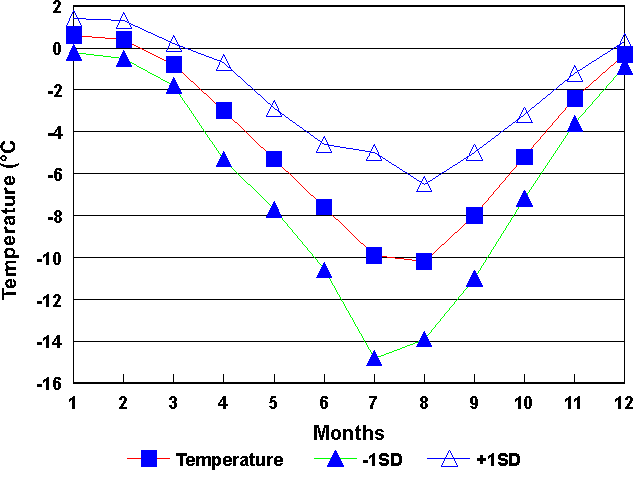
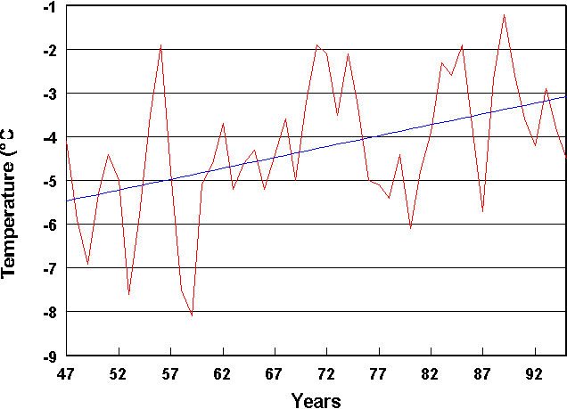
The annual mean temperature at Faraday is -4.3 C with a standard deviation of the annual means of 1.5 C.
The graph of monthly average values of temperature for Faraday show that January is the warmest month (+0.6 C) and August the coldest month (-10.2 C). The standard deviation of the temperature is much greater in the winter than in the summer differing by a factor of four. This is due to the variable sea ice cover which gives Faraday a broader temperature range in the winter than if there were open water all year round.
From the graph of annual average temperatures an increase in the average temperature of 2.5 C over the 48 year time series can be seen and this equates to a rise of just over 0.5 C per decade.
The table below gives the percentage of monthly average temperatures in specified ranges. Temperatures in the summer months are confined to a much smaller range than those in winter.
| Range | JAN | FEB | MAR | APR | MAY | JUN | JUL | AUG | SEP | OCT | NOV | DEC |
| 0 to 5 | 87 | 77 | 31 | - | - | - | - | - | - | - | 3 | 33 |
| -5 to -0.1 | 13 | 23 | 69 | 92 | 69 | 28 | 18 | 7 | 26 | 53 | 97 | 67 |
| -10 to -5.1 | - | - | - | 5 | 26 | 60 | 41 | 49 | 54 | 47 | - | - |
| -15 to -10.1 | - | - | - | 3 | 5 | 10 | 23 | 31 | 20 | - | - | - |
| -20 to -15.1 | - | - | - | - | - | 2 | 15 | 13 | - | - | - | - |
| -25 to -20.1 | - | - | - | - | - | - | 3 | - | - | - | - | - |
The next table shows the extreme maximum and minimum temperatures; there is large variability in the range of temperature at Faraday. The range in the winter is much greater than in the summer due to the sea ice in the winter (King 1994).
| JAN | FEB | MAR | APR | MAY | JUN | JUL | AUG | SEP | OCT | NOV | DEC | |
| MAX | 10.9 | 8.3 | 8.8 | 7.6 | 7.9 | 6.4 | 5.1 | 4.5 | 4.8 | 7.9 | 7.1 | 10.0 |
| MIN | -10.0 | -8.3 | -13.6 | -32.8 | -30.6 | -33.8 | -39.4 | -42.4 | -37.2 | -30.0 | -19.8 | -9.4 |
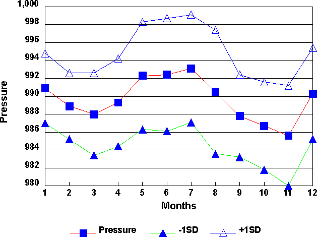
The yearly average sea level pressure at Faraday is 989.8 hPa with a standard deviation of the annual means of 1.3 hPa.
From the graph of monthly mean values of pressure a distinct semi-annual oscillation can clearly be seen with the pressure minima occurring in March and November and pressure maxima occurring in December and July. The standard deviation is fairly high as Faraday is situated in the circumpolar trough which is the path that the majority of the depressions, moving in from the west of Faraday, take.
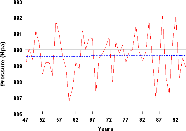
The graph of yearly values shows that there is no trend in the pressure values. It does however show the large interannual variability in the mean pressure.
The table below shows the extreme and monthly maximum and minimum pressures. There is a large range in all months of the year. This is due to the fact that Faraday lies in the circumpolar trough and so the pressures ranges vary as the cyclonic activity varies.
| JAN | FEB | MAR | APR | MAY | JUN | JUL | AUG | SEP | OCT | NOV | DEC | |
| Max. | 1016.8 | 1019.7 | 1025.7 | 1026.2 | 1033.2 | 1027.1 | 1031.8 | 1029.2 | 1027.4 | 1026.0 | 1024.4 | 1025.7 |
| Month Max. | 999.3 | 999.6 | 998.5 | 999.4 | 1002.8 | 1007.1 | 1005.2 | 1008.7 | 999.7 | 1000.8 | 1002.6 | 1003.4 |
| Min. | 952.6 | 956.0 | 952.3 | 940.9 | 935.6 | 943.4 | 948.8 | 936.6 | 934.5 | 946.6 | 948.6 | 952.0 |
| Month Min. | 982.4 | 979.9 | 978.1 | 978.0 | 980.1 | 980.0 | 981.4 | 978.1 | 979.5 | 975.0 | 972.1 | 981.7 |
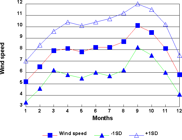
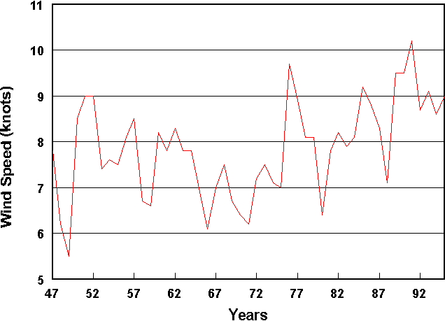
The annual mean wind speed at Faraday is 7.8 knots with a standard deviation of the annual means of 1.0 knot.
The graph of monthly mean wind speed valuesshows that the average mean wind speed is highest in spring with a maximum in September where the mean is just over 10 knots. January and December have the lowest wind speeds with a mean of less than 6 knots.
The graph of annual average wind speed indicates a large inter-annual variability. There has been a slight increase over the time series. This slight change over time may be real or it may arise from changes in the site from which the wind speed was measured or changes in the equipment used to measure wind speed.
The table below shows the maximum recorded 10 minute mean wind speeds and that these are highest in the spring.
| JAN | FEB | MAR | APR | MAY | JUN | JUL | AUG | SEP | OCT | NOV | DEC |
| 40 | 38 | 40 | 48 | 45 | 46 | 50 | 52 | 50 | 59 | 42 | 48 |
The monthly wind roses illustrate that the wind direction is generally from the north or the south and very rarely from the west or northwest. This is due to topographical steering of the lower tropospheric flow by mountain ranges on the Antarctic Peninsula and surrounding islands. The percentage of calms are shown in the inner circle.
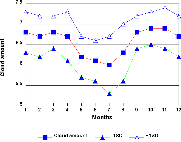
The graph of mean total cloud cover, in oktas, at Faraday varies little from month to month. The mean amount is always between 6 and 7 oktas. There is a slight drop in the total cloud cover during the winter months of May to August.
The time series of yearly averages ( not shown) shows some inter-annual variability and although there has been a slight increase in the mean between 1956 and 1995 it is only about 0.1 oktas per decade.
Precipitation occurs at Faraday in both liquid and solid forms. The majority of the precipitation falls as snow with precipitation occurring in about 30% of all reports i.e. about 30% of the time. There are more reports of precipitation in the spring than other seasons reaching 27% in September.
The table below shows the percentage of total number of synoptic reports associated with different forms of precipitation.
| DRIZZLE | RAIN | SNOW | |
| JAN | 1.9 | 9.4 | 13.5 |
| FEB | 2.0 | 11.7 | 27.0 |
| MAR | 1.9 | 9.7 | 22.0 |
| APR | 1.5 | 5.9 | 25.0 |
| MAY | 1.5 | 3.5 | 23.5 |
| JUN | 1.2 | 1.8 | 26.8 |
| JUL | 1.2 | 1.4 | 27.7 |
| AUG | 1.1 | 2.3 | 28.9 |
| SEP | 1.2 | 3.9 | 32.0 |
| OCT | 1.3 | 3.9 | 31.6 |
| NOV | 1.2 | 5.3 | 26.6 |
| DEC | 1.3 | 7.4 | 19.0 |
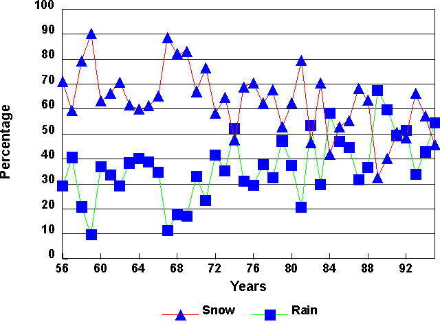
This graph shows the percentage of solid and liquid precipitation during summer (December, January, February). The percentage of liquid precipitation has increased from about 30% to 50% during the past 40 years and this is discussed further by Turner at al.
Due to the lack of atmospheric pollution in Antarctica, the visibility is only reduced by precipitation, fog, mist, blowing snow or low cloud. The visibility reported in the synoptic codes is split up into the following ranges. Code Visibility range 90 <50m 91 50m - 200m 92 200m - 500m 93 500m - 1km 94 1km - 2km 95 2km - 4km 96 4km - 10km 97 10km - 20km 98 20km - 50km 99 >50km
The table below gives the percentage of the time that the visibility is in each range by month between 1956 and 1995. It can be seen that for the majority of the time the visibility is 10 km or greater.
The percentage of lower visibilities (< 1km) in spring is higher than in autumn and this is consistent with the fact that there are more precipitation events in spring (Table 6).
| 90 | 91 | 92 | 93 | 94 | 95 | 96 | 97 | 98 | 99 | |
| JAN | 0.00 | 0.3 | 1.1 | 1.5 | 2.4 | 4.0 | 9.6 | 13.6 | 34.0 | 33.5 |
| FEB | 0.00 | 0.2 | 0.9 | 1.4 | 2.8 | 4.3 | 12.1 | 16.4 | 32.2 | 29.8 |
| MAR | 0.00 | 0.2 | 0.8 | 1.8 | 3.8 | 5.9 | 15.2 | 16.8 | 31.9 | 23.5 |
| APR | 0.02 | 0.2 | 1.0 | 2.1 | 4.3 | 6.3 | 15.2 | 17.7 | 32.1 | 21.2 |
| MAY | 0.00 | 0.4 | 1.3 | 2.9 | 4.7 | 5.3 | 13.4 | 15.6 | 32.6 | 24.0 |
| JUN | 0.01 | 0.2 | 1.1 | 3.7 | 4.9 | 5.4 | 15.4 | 15.4 | 29.9 | 23.9 |
| JUL | 0.01 | 0.2 | 1.6 | 4.8 | 5.4 | 6.0 | 15.9 | 13.8 | 29.5 | 22.8 |
| AUG | 0.07 | 0.5 | 1.9 | 5.5 | 6.4 | 7.0 | 14.6 | 14.7 | 29.7 | 19.6 |
| SEP | 0.03 | 0.4 | 2.1 | 6.5 | 6.8 | 7.5 | 16.5 | 15.3 | 28.5 | 16.4 |
| OCT | 0.01 | 0.4 | 1.7 | 5.4 | 6.7 | 7.2 | 14.9 | 14.6 | 29.4 | 19.7 |
| NOV | 0.01 | 0.4 | 1.4 | 3.5 | 5.0 | 6.7 | 13.8 | 16.0 | 30.7 | 22.6 |
| DEC | 0.01 | 0.4 | 1.0 | 1.8 | 3.0 | 4.6 | 10.5 | 14.3 | 33.7 | 30.8 |
(1) King, J.C. 1994. Recent climate variability in the vicinity of the Antarctic Peninsula. International Journal of Climatology, 14 , p 357-369.
(2) Turner, J., Colwell, S.R. and Harangozo, S. 1997. Variability of precipitation over the coastal western Antarctic Peninsula from synoptic observations. Journal of Geophysical Research, No. D12, p 13999-14007.
(3) Gardiner, B.G. and Shanklin, J.D. 1989. Measurements of Solar and Terrestrial Radiation at Faraday and Halley. Internal BAS report 45 pp.